
Letter from the Fringe, 2019: Geology and History go Hand-in-hand
- Jeffrey Nytch
- Aug 10, 2019
- 7 min read

Updated: Aug 25, 2019
One of the things that I have always loved about geology, and keeps me learning about it, is the myriad ways it influences human history. Whether it be the presence of mineral deposits that fuel economies, the formation of a deep harbor that facilitates trade and cultural exchange, or the availability of water to serve communities and agriculture, geology has always been one of the key shapers of our civilization. Despite having such a profound impact on our history, and it co-existing right beneath our feet, geology remains only vaguely understood by most citizens; they go about their business without thinking that events from millions, even billions, of years ago are shaping their daily lives.
One of the best and most visible ways to see how geology shapes history is to look at the location and construction of the great fortresses and castles of old, and few provide a more beautiful example than Edinburgh Castle.
The castle rests upon Castle Rock, the remains of a volcanic “plug” (the innards of a volcano) that are far more resistant to erosion than the surrounding sandstone. Glacial erosion carved away some of that sandstone during the last Ice Age, exposing the imposing bluff we see today. The result is an imposing and impenetrable feature that is a natural site for a fortress.
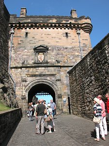
Archeological evidence suggests there may have been human habitation atop the rock as early as the Bronze Age. The Romans (before they were run off by the Scots) noted settlements in the area as well. The Rock has been the site of a Scottish castle since the 12th century, and since then it has been the target of no less than 26 sieges – making it the most attacked fortress in Britain and one of the most targeted castles in the world. While several of those sieges ended in a negotiated surrender of the castle, none of them ever ended as a result of armed entry into the defended fortress. When you visit the place it’s not hard to see why: the igneous rocks making up Castle Rock create sheer cliffs that tower several hundred feet above the valley below, and the walls of the castle seem to rise out of the living rock. The only access is via the narrow spur that now makes up High Street, a spur which ends with a huge moat and a well-defended gate at the end of a narrow, canyon-like lane. Getting any volume of soldiers all the way to the gate would be nearly impossible: being forced to navigate the narrow path would make the invaders sitting ducks to the defenders above.


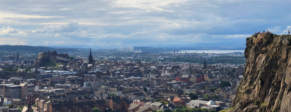
A more dramatic, “big picture” view of how all this geology plays out can be found on Salisbury Crags, which tower over the city and represent the remains of a much larger volcanic formation of which Castle Rock is but one outgrowth. From the Crags you can both see how the castle is perched above its surroundings and also appreciate the 360-degree view that the castles’ defenders could take in as they kept their eyes out for invaders. It would simply not be possible to move a force of any size close to the castle without being detected well in advance, further strengthening the impenetrable nature of the fortress.

A close-up view of Castle Rock from the Crags, as well as the view in the other direction towards the seaport of Leath and the Forth Estuary:


Given the importance of Edinburgh Castle throughout Scottish history, it’s no understatement to say that geologic events from 70 million years ago played a defining role in shaping that history. Quite literally, Scotland would not be the country it is today without it.
Here is a more detailed geologic history I pulled together for the members of our company who had asked me about it. I hope you find it interesting!
A Quick Overview of the Geology of Scotland
So there are three things to know about the geologic history of this part of the world, and they can be seen in the map at the end of this entry.
1. It’s a history involving a series of plate tectonic events called orogenies (yes, say that word carefully!), which are mountain-building events caused either by two or more bits of continental crust colliding (think sub-continent of India slamming into Asia to form the Himalayas), or when arcs of volcanic islands collide with either each other or other bits of continental crust (the volcanic arcs of Indonesia being the closest current analogue). There are several orogenies with remnants in modern Scotland:
Grenville Orogeny: This was about 1.2 billion years ago. It’s called something different in Europe but it’s the same basic event and it was massive, forming a huge mountain range from what is now northern Europe all the way through Greenland, northeastern Canada, and northern New England to what is now northern Mexico. There are even effects of the Grenville Orogeny found in Colorado! (These are depicted as the second of the big climaxes in the first movement of my geologic symphony.)
Paleozoic orogenies: Taconic & Acadian-Caledonian: During the Paleozoic (from about 500 million years ago to 270 million years ago) there were a series of orogenies as various earlier continents began to sort of pile up. The details are incredibly complex; suffice to say there was a lot of jostling. The Taconic orogeny formed the bedrock of southern New England and eastern NY state, and the erosion of those Taconic mountains filled a basin to the east with sedimentary rocks that can still be found in Scotland today (Cambrian, Ordovician, and Silurian on the map). Then the “big one” occurred, called the Acadian Orogeny in North America and the Caledonian Orogeny in Europe (“Caledonia” being the Latin designation for Scotland). This orogeny took place over many millions of years and extended from northernmost North America & Europe to the southern Appalachians – and it unfolded in roughly that order, too: picture a zipper being zipped up from north to south, as first northern Europe, then southern Europe, then Africa gradually collided with North America. By the time it was over the combined continents formed Pangea – the last time we had a “super-continent” of all the continental crust on the planet glued together – and the resulting mountains were as high as the modern Himalayas. The remnants of those mountains are today’s Appalachians. (Or think of it thusly: in 300 million years or so, the Himalayas will likely resemble the Appalachians today.)
During this time, there was also volcanic activity in this part of Scotland, which kind of surprises me. This was not associated with an active plate boundary – neither a subduction zone or a continental collision, but there was clearly enough shuffling of plates and enough active plate boundaries nearby to generate igneous activity – some of which remained underground and others of which made it to the surface and formed volcanoes. Volcanic activity returned much more recently (67 mya-55 mya), most likely associated with the spreading of the North Atlantic Ocean (more below).
2. The second thing to keep in mind is that the geologic histories of Scotland and northeast North America are very closely linked. It wasn’t until the modern North Atlantic started to open up that they were finally torn asunder and moved thousands of miles apart. But what’s interesting about this split (to me, anyway!) is that the point of splitting was not along a previous suture – which you might expect. See, continents are often like bones: when they break and are put back together, the point of healing/suturing is actually stronger than the bone around it. I’m not sure why that is with bones, but it’s frequently that way with continents because the mechanism for “gluing” them together is a lot of heat and pressure. The rocks are transformed (metamorphosed), previous planes of weakness – like the boundaries between sedimentary layers or faults that were a result of the collision – are erased. And the resulting suture is stronger than the rocks around it. So when ocean spreading starts up again, it’s usually along new axes. What causes a continent to start splitting apart like this? What begins the process is actually still something of a mystery, and it doesn’t always work: so-called “failed rifts” are common precursors to the rift that finally takes hold. Before the Atlantic opened up, for instance, there were a whole string of failed rifts in what is now the eastern U.S. (One of those – the Hartford Basin of Connecticut, which carries the modern Connecticut River – was to be the site of my masters thesis. I did all the preliminary research but instead of spending a summer in the field and writing my thesis I dropped out and applied for grad school in music. J ) I’m not sure if there were any failed rifts on this side of the pond, but I don’t think so (at least not in Scotland). The most recent volcanoes were probably just the last sort of spitting of stray plumes from the spreading center – that was a lot closer to Scotland 60 million years ago than it is today!
3. The last thing to remember is that Scotland was covered by glaciers in the last Ice Age. This means that the modern topography was largely carved out by glaciers up to a mile thick; first as they scraped and gouged the surface and then, as they melted, by the massive amounts of meltwater surging down valleys and filling lakes. But the glaciers, as powerful as they were, were nonetheless guided by the existing geology. For instance, the deep but narrow lochs were carved out along previous planes of weakness created by (drumroll please) the Caledonian Orogeny. The volcanic rock of Arthur’s Seat and the Castle Mound was more resistant to erosion than the surrounding sedimentary rock, so as the glaciers and their meltwater carved and eroded their way across the surface, the weaker rock went first and the harder rock was left in relief.
And of course this is where I make the obligatory comment about how of this is still going on: the planet is not static. The Mid-Atlantic ridge continues to push the Americas apart from Europe and Africa (at about 1-2 inches a year). Erosion continues to shape the landscape. The African plate continues to rub up against Europe, fueling the volcanoes of Italy and lifting up the Alps. And down on the other side of Africa, in the East African Rift Valley, we have a new ocean spreading center trying to establish itself. Whether this will turn out to be a failed rift or actually split the horn of Africa apart to form its own new continent will only be known in time.


Comments